Summary: Typhoon No. 30 (international name: Champi) is a large, violent typhoon south of Okinawa. The Japan Meteorological Agency (JMA) expects it to approach the Sakishima Islands (Miyako and Yaeyama) on Friday 23 and Saturday 24 October. Even far from the storm, a rain front may bring heavy rain to Kyushu and the Sea of Japan side over the weekend. If you live in Okinawa or Kyushu, use today and tomorrow to secure things outside, prepare for power and water cuts, and check where you would evacuate.
This article is based on JMA’s typhoon information issued at 06:45 JST on 22 October, and on guidance from the Japan Weather Association and local governments (checked: 2026-10-22). The track can change, so check the latest forecast before you go out or go to bed.
Where is Typhoon No. 30 now?
At 06:00 JST on 22 October, JMA placed the typhoon south of Okinawa, moving northwest at 20 km/h.
- Size and strength: “large” and “violent” (JMA’s highest intensity class)
- Central pressure: 905 hPa
- Maximum sustained wind: 55 m/s (gusts up to 80 m/s)
JMA’s forecast from the same bulletin:
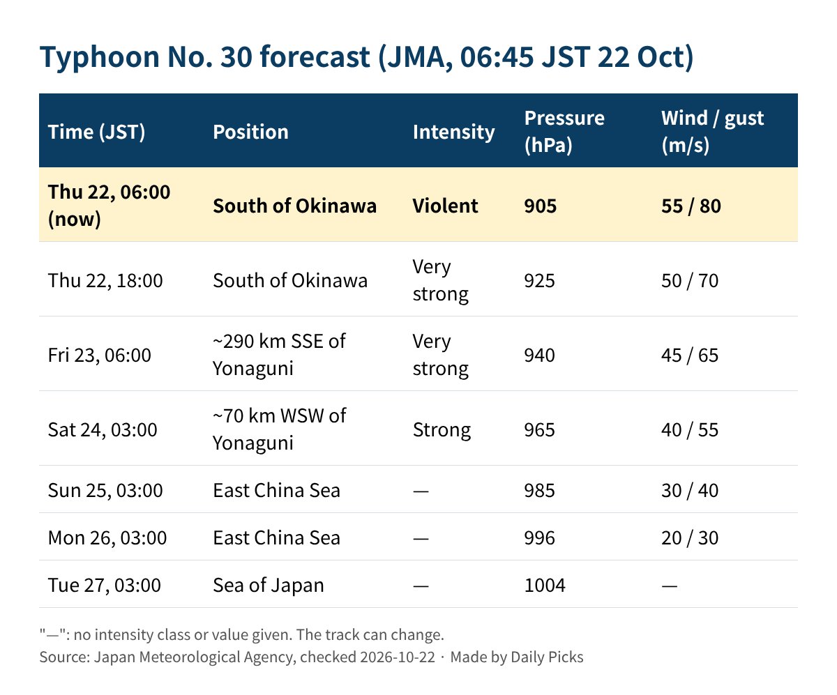
Checked: 2026-10-22 (JMA, 06:45 JST bulletin).
The Japan Weather Association (tenki.jp) said on 21 October that the typhoon is expected to turn northeast after moving into the East China Sea on the 24th, and to become an extratropical low near the Tsushima Strait around Monday 26 October. It may come close to Kyushu, so people there should keep watching even as it weakens.
Who is affected
- Okinawa (especially the Sakishima Islands): the Japan Weather Association expects extremely strong winds from Friday 23, with gusts up to 60 m/s forecast, strong enough to collapse some houses. Waves of 11 m are forecast for the 23rd
- Amami: high waves from the 22nd to around the 24th
- Kyushu: warning-level heavy rain is possible across a wide area on Saturday 24
- San’in and Hokuriku (Sea of Japan side): a medium chance of heavy rain warnings on Sunday 25
The rain is linked to an autumn rain front that tends to stay near Honshu. The typhoon moving north can make that front more active, so rain can get heavy before the typhoon itself arrives.
What you can do now (before the wind picks up)
These steps follow the typhoon checklist published by Chuo City, Tokyo.
- Bring in or tie down loose items. Plant pots, laundry poles, bicycles and anything on your balcony can be blown away and break windows.
- Clear drains. Remove leaves and rubbish from gutters and drain covers, and do not put things on top of street drains.
- Protect windows. Use shatter-resistant film, or at least close curtains or blinds so broken glass does not fly into the room.
- Prepare for power and water cuts. Store drinking water, food and a portable toilet. Charge your phone and a power bank, and check torch batteries. Our emergency kit checklist works for typhoons too.
- Check your hazard map. Your city or town publishes a hazard map (hazādo mappu) that shows flood and landslide risk. Decide where you would go and how you would get there, and plan to move in daylight.
How to read warnings in Japan (new names since May 2026)
Since 29 May 2026, JMA has shown heavy-rain information together with a warning level number from 1 to 5. For example, a heavy rain warning is now called a “Level 3 heavy rain warning”.
- When Level 3 or Level 4 information is issued, check JMA’s Kikikuru risk map and river levels for your area.
- If your city issues a Level 4 “evacuation instruction” (hinan shiji), evacuate quickly.
- If going to a shelter is dangerous, move to the upper floor of a strong building away from rivers and cliffs. JMA says the best safe action at that moment matters more than reaching a designated shelter.
To get alerts in English on your phone, the app Safety tips (introduced by the Japan Tourism Agency) sends earthquake early warnings, tsunami warnings and JMA emergency warnings, including storm and heavy rain emergency warnings, in five languages including English, as the Kanagawa Prefecture page below explains. In an emergency, call 119 for fire and ambulance or 110 for police. Our guide to emergency numbers in Japan explains which number to use.
If you are travelling
Flights and ferries to and from Okinawa and Amami, and transport through Kyushu at the weekend, may be cancelled or delayed. Check the airline, ferry or rail company’s official website or app the day before and on the day of travel. Rules for changes and refunds are announced in each company’s official notices.
FAQ
Q. I live in Tokyo or Osaka. Do I need to do anything?
A. JMA’s forecast moves the typhoon into the East China Sea and then the Sea of Japan by around the 27th. Even far from the storm, the rain front may bring heavy rain this weekend, so check the forecast and warnings for your area. The track can still change.
Q. Should I tape my windows?
A. The local government guidance recommends shatter-resistant film or closing curtains and blinds. Do any work outside before the wind gets strong. Going outside in a typhoon is dangerous.
Q. Where can I see official typhoon information in English?
A. JMA’s typhoon map is available in English (switch the language at the top of the page). Your city’s website may also have English or “easy Japanese” (yasashii nihongo) notices.
Q. What does “violent” mean?
A. It is JMA’s top intensity class for typhoons, used when maximum sustained winds reach 54 m/s or more. JMA forecasts the typhoon to weaken to “very strong” and then “strong” as it moves north.
Related reading
- Earthquake emergency kit (bosai bag) for foreign residents
- Emergency numbers in Japan: 119, 110 and #7119
Sources (checked: 2026-10-22)
- Japan Meteorological Agency: Typhoon information (Typhoon No. 30, 06:45 JST, 22 October)
- Japan Meteorological Agency: New disaster-prevention weather information (from 29 May 2026, Japanese)
- Japan Weather Association (tenki.jp): Typhoon No. 30 and the weekend rain front (21 October, Japanese)
- Chuo City, Tokyo: Preparing for typhoons (Japanese)
- Kanagawa Prefecture: Disaster information app “Safety tips”